Showing posts with label skiing. Show all posts

Wednesday, June 05, 2013

Lyngen in May, a ski-mountaineering trip report (part II)

Part II of this account is just a day by day account of what I did on this recent trip and might give some ideas for routes for anyone else interested in skiing in Lyngen. The maps below are screen grabs from the Norwegian national mapping website, and I've just drawn a line on them - it's not a GPS track so only shows approximately the routes I took.

Sunday: Jiehkkevárri (1834 mtrs) via Holmbuktind (1666 mtrs).
 
Jiehkkevárri, taken later in the week from Ellendaltinden. The summit is the central high snow dome. Holmbuktind is the peak on the far left. The traverse between them follows the skyline.

I would imagine this is going to feel like a big day for all but the most ludicrously fit; my friend measured about 2,300 mtrs of ascent. We had a very good avalanche forecast which made the double bowl that is the route up Holmbuktind feel OK. It gets pretty steep in a couple of places, some people took skis off for a short section coming up into the upper bowl, but I felt fine on skis even though I don't have heel bars on my bindings. Leaving the upper bowl and coming out onto the ridge there is another short steep bit, most seemed to take off their skis and I was happy to crampon that bit although some did just in boots. The ridge itself to Holmbuktind is easy enough going up but a serious place to ski coming back down, you wouldn't want to go off either side.

Coming out of the bowls onto the summit ridge of Holmbuktind
From the summit of Holmbuktind you drop down (east) to the col between it and Jiehkkevárri (serious ground on your right). there was one short steeper section a bit after the col that I needed to put crampons on for, but after that its just knackering skinning for another couple of kilometres and some 200 mtrs of ascent to the summit. All of this is a glacier but we saw no signs of crevasses or bergschrunds.
Skiing back across the Jiehkkevárri across the plateau
 You reverse the route to descend. Going back up to the summit of Holmbuktind is pretty morale sapping but the ground gets too steep too quickly to try and take a traverse line below its ridge. Coming off the ridge and back down into the bowl there is probably the steepest bit - my experienced team mates estimated at 35 degrees. They swooped down it being good skiers. Being mediocre, I side slipped which was fine. After that its was all pretty fantastic skiing on spring snow right back down to the last kilometres through the afternoon gloop in amongst the trees. I fell over a lot here and used many rude words, taking skis off though is no help as you'll go crotch deep into the hell-snow. Trying to keep a sense of humour is probably the most important thing and tell yourself its only another few hundred metres back to the car!

Big drops either side - careful skiing back down Holmbuktind's summit ridge.

Fantastic skiing above the sea.

The last of the great spring snow, back down to the trees.


Monday: Middagstinden (1072 mtrs). 


Middagstinden from the house we stayed in.


Steep skinning, Piggtinden's summit behind.
 This hill was right behind our house so an easy target after a long morning of drinking coffee and recovering from the big day before. Considering that this is still about a 1000 mtrs of ascent, we seemed to shoot up Middagstinden; I think we were up and back down in under three hours. Once out of the trees it's a pretty steady ascent up the west flanks. If you keep towards the ridge (south) you both minimise being on open slopes and get great views over to Piggtinden and it's amazing ridge. Skiing down was fantastic on first powder then great, firm spring snow. Once back in the trees I found what must be a track in summer and followed that back down coming out right by our house, avoiding the difficult slush skiing through the trees that had finished the day before.


Looking back up at the great slopes we descended.

Tuesday: rest day.  

Heavy rain at sea level. Some of us went to Tromsø for some shopping. I visited the the North Norway Art Gallery which was both interesting and free!
They grow 'em tough up north.


Wednesday: the lower slopes of Blåtinden. 


Blåtinden from the lower slopes.
Some of the team went fishing in the morning rain, so after lunch myself and the fellow telemarkers of our group, Olli and Mikko, decided to go and check out the skiing conditions. Blåtinden isn't strictly part of Lyngen, its a well known ski peak in the Tromsø Fastland area, but only about 15 minutes from where were staying. We went light without axes or crampons and this meant we thought the upper slopes looked uninviting: either wind-scoured and icy or loaded with the fresh snow that had fallen in the last two days and blown in the hard wind from the now scoured areas. We figured that all the rain at sea level was fresh snow up high and it would have been moved a lot by the strong winds and therefore we wouldn't be missing much besides slog and possible windslab risk higher up. Nevertheless we met the unsuccessful fishermen, Dave, Okke and Roger, as we headed down and they went all the way up reporting that actually the conditions on the upper half were fine. Oh, well - a summit for another time.

Above Balsfjord.

Olli making tracks down next to our track up.

Thursday: Tomastinden South Summit (c. 1525 mtrs).

Tomastinden in the evening light. Don't worry you don't go up from that side!
 The route finding is pretty easy on this one, from Lakselvbukt you go straight up the bloody, big couloir above the village (Tomasrenna). This we found mainly skiable although we bootpacked maybe the last couple of hundred metres. From here you emerge on to a wonderful glacial plateau, nicknamed the 'place of heavenly peace' surrounded by the Lakselvtindane peaks.
The skin track in up the Tomasrenna

The wonderful 'Place of Heavenly Peace'
With the other telemarkers again I headed to the south summit of Tomastinden which appears to be the regular "skiers peak" - the actual summit is a few metres higher at 1554 but would require climbing gear to reach. Skiing back down from this peak was great in powdery snow then a schuss back across to glacier to the top of the Tomasrenna. I realised coming up that this was going to be beyond my skiing skills on the return, so I cramponed down the first few hundred metres before going back to skis. For strong skiers in our party this was amongst their favourite bits of skiing on the trip. For me, it was a bit to tough going to be really fun, but there is some satisfaction to be gained in just doing something difficult for you, and doing it safely.
A Norwegian skier dropping down from Tomastinden's south summit

Olli and Mikko skiing back down the Tomasrenna.

Friday: Ellendaltinden (1345 mtrs).

Ellendaltinden (centre) and Langsdaltindane (right) from Tomastinden. The approach goes up the valley between the two.
After the 'big thursday', the Telemark team decided maybe to try something a bit easier for Friday. In one sense Ellendaltinden was difficult. Most of the skiing was straightforward although the last summit cone was covered in thick, hard sastrugi, so we left our skis at the col and bootpacked the last bit. But on the other hand, whilst beautiful, it was a long ski up Ellendalen - probably the the most distance we covered all week. 
The valley approach starts along snowmobile tracks.

Higher, looking back down and westwards.

The mighty north wall of Langsdaltindane, around 700 mtrs high.
 On the return a lot of this is just schussing, and in the afternoon sun we even had to pole a bit on the flatter sections. Nevertheless, its a fantastic viewpoint and you can seen right across Lyngen, and back in land to Sweden and Finland from the summit. Again, here the skiers summit is slightly lower than the true summit, but perhaps on by a metre or two; and getting over to the true summit looks really rather tricky!
Swinging round to climb westward up the open easy summit slopes; great skiing coming back down.

Mikko on the summit, looking south into the valleys that go up to Sweden and Finland.

Hiking back down to the col where we left our skis.
After six days of great skiing, everyone back down safely. Enjoying a beer in the afternoon sunshine. Thanks guys for the great trip!

Tuesday, May 21, 2013

Lyngen in May, a ski-mountaineering trip report (part 1)

Telemarks off Holmbuktind (1666 mtrs), the summit ice cap of Jiehkkevárrio (1834 mtrs) that we had just climbed is behind me. Thanks to Dave for this photo.
I had never heard of Lyngen before moving to Finland despite having been pretty immersed in British climbing culture for a good number of years by that point. It's odd in a way because most of the first ascents in the region were done by British climbers visiting by ship around the start of the twentieth century. The region has seen some other British visitors as well down the decades, ascents of many of the major Lyngen peaks are described in Peter Lennon's “Scandinavian Mountains” from 1980s and Joint Services mountaineering teams did winter training in the area before that. Nevertheless, in the 1990s I don't remember any magazine articles about the area nor had I heard anything about British climbers visiting; it really seemed back then that, besides locals, the area was a Finnish playground – indeed it's much closer in driving time to Helsinki than it is to Oslo.

After 16 hours in the car, welcome to Lyngen (Piggtinden 1505 mtrs).

When I first went I was awestruck by the place – both by its beauty and by its seriousness. It was relatively early in the winter - February I think; there was a lot of snow and a lot of avalanche activity. We camped and needed to melt snow for water all week. At night the temperatures got as low as -27. It felt like a total expedition experience and partly as a consequence of this we didn't get huge amounts done – just being; staying safe and comfortable in those kind of conditions takes some work. I've now been back almost ten times, sometimes to ski, sometimes to ice climb, even once in the summer to climb on rock. I feel I'm just about starting to get a feel for the place, but even though I've rarely camped since, finding you get much more done with a warm shower, meal and bed each night, it hasn't stopped feeling serious.
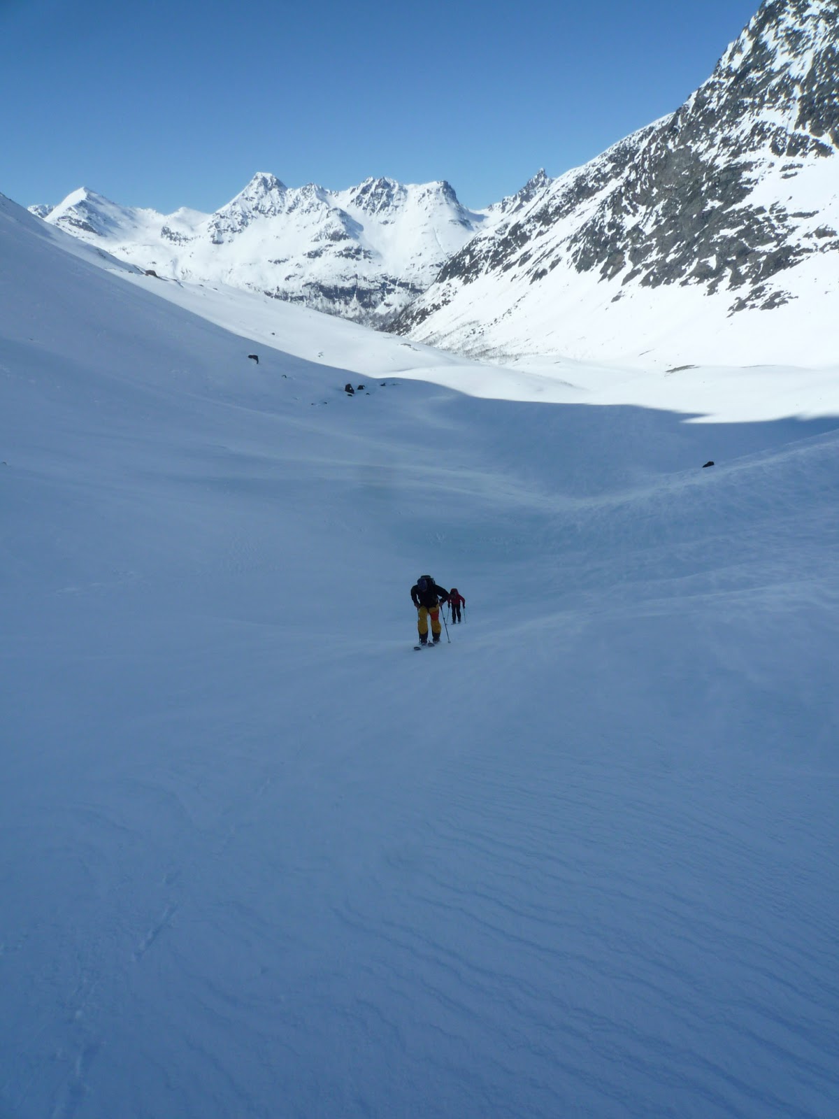
This is the Arctic. Crossing Jiehkkevárri's ice cap on the way back over to Holmbuktind. Dave and Okke are just visible on the left giving the cornice/serac on the right a wide berth.

If anything has changed in the 15 years that I've been going to Lyngen, it's other people going as well. On this trip we followed others skiers tracks most days – that wasn't the norm a decade ago where you would often be breaking trail and have the whole mountain as your canvas. Having not ski-toured in the Alps I can't really compare it, but I get the sense that despite Lyngen's huge rise in popularity, it is still not exactly crowded compared to more well known ski-touring destinations. On this trip I was the youngest participant and I feel old more often than not, so we did sensible things as middle-aged men should.
Late season; aesthetically pleasing tree wells but keep your skis out of them!

We gave up a day to do the drive, making an early start from homes in the south of Finland, getting to our rented house in Lyngen by mid-evening. Yes, you can drive through the night and maybe get something done on your arrival but that's a young man's game. We ate wonderfully, in no small part thanks to the cooking talent of my trip mates. Wild boar, fresh halibut, shrimp straight from a trawler in Tromsø, authentic classic Chinese food from a former Beijing resident and even – I'm vaguely ashamed to admit – whale steaks. Yes, it would be illegal in the EU, but Norway isn't and they sell it in the supermarkets there. I just wish it hadn't tasted as good as it did.
Skinning up Middagstinden (1072 m), Balsfjorden in the background.

It was also our first trip in May – the date was chosen as much as anything else because the trip was a sort of a celebration of one of the team's imminent scoring of the big half century – but the decision turned out to be pretty successful from a skiing point of view too. We skied from the car each day which – in Lyngen – means from virtually sea level. Coming back down in the afternoons this meant that lowest slopes, often flat or near to it and through trees could be rather hard going with numerous falls into bottomless wet gloop. Not falling over is the obvious solution, although I'll blame it on my now rather old, narrowish skis rather than my poor skills. Higher we had everything from wonderful open slopes of sun-warmed spring snow, the odd icy sections and not inconsiderable amounts of powder. You can't ever stop thinking about avalanches in Lyngen – it is a serious place in that respect but earlier warmer weather had homogenized much of the snowpack making the base rather stable. We did see lots of full depth slips on lower slopes from strong sun, often off rock bands, but staying away from those areas was easy enough.
Nearly back to the road, as can be seen even at a height of only 100 mtrs there is plenty of snow left in mid May.

Skinning in Lyngen is always an education in grind although I found myself going well on this trip and was fairly often was at the front of group. We had one rest day out of our seven days up there, and in the other six I worked out I did 6750 mtrs of ascent – I reckon 90 percent of that on skis; boot packing and cramponing was kept to a minimum. I think that cycling a fair amount helps prepare for this and mentally I don't hate the grind as much as when I was younger.
Mikko skinning above Balsfjord on the slopes of Blåtinden (1180 mtrs), although we didn't go to the summit that day.

I had only skied for literally four or five days on alpine gear before I bought my own telemark gear, so I've been telemarking now for just shy of 20 years and can't really remember what it is like to have your heels attached. After this trip I think it might be time to bite the bullet and accept I just don't have the money and/or the access to good lift skiing to get better at telemarking and try AT kit as an alternative. I'm not a total disaster and my tele skills have been enough to take me for some of the best days I've ever had in the mountains. I also suspect that some newer, better gear would help a bit as well, my kit is over a decade old now. I can ski any piste in Finland confidently and relatively competently on the gear I have but mountain skiing is a harsh teacher. Crust, grabby snow, deep wet snow, even light fluffy powder can punish my okay-but-not-brilliant technique honed on the, mainly icy, pistes of Scotland and Finland. On this trip we also skied in a number of places where falling would be a bad to really bad idea. I cramponed down the first couple of hundred metres of one of the big couloirs where my friends jump-turned, and I side-slipped another steep section – maybe about 35 degrees – where again my friends on AT gear were skiing hard and fast. Being able to climb in ski boots is also a big attraction to clamping my heel back down. I can put my G12s on my tele boots and it's OK for steep snow but tenuous when on anything remotely technical. There's something fun about telemarking; even with its continuing rise in popularity it's still to be part of a special club – although perhaps that's a club of people who insist on making life more difficult than it needs to be!
About halfway up the Lakselvtindane massif; Lakselvdalen and Lille Piggtinden behind.

The standout day for me was doing Jiehkkevárri, the highest peak in Lyngen at 1834 mtrs. It is something of a mountaineering challenge as despite being topped by a large flatish ice cap, there is no easy direct way to approach it. The 'standard' skiers route we took first goes to the top of its neighbour, Holmbuktind (1666 mtrs). It was fairly busy up there with lots of other teams making an ascent, but few others decided as we did to drop down to the col to its north and then begin the plodding re-ascent to Jiehkkevárri's eventual top, about another 3.5 kms on. You will have done about 2,300 mtrs of ascent by the time you reach its top.
Olli and some Norwegian guys on the "skiers summit" of Tomastind, just a few metres lower than the difficult to reach 1520 mtr main summit. The view is eastwards across the interior of the Lyngen peninsular.

Being an ice cap and flat there is nothing to mark the highest point beyond some ski tracks of earlier visitors and other signs of their passage: dropped lunch crumbs and yellow stains in the snow a few metres away. But that didn't matter. After numerous visits to Lyngen, spending probably a couple of months of my life in that magical area along with the hundreds of indifferent cups of coffee drunk in Finnish petrol stations to fuel that tedious 16 hour drive up; I had made it to the top. I might not be the most stylish or hard-charging skier going back down, but getting to the top of Jiehkkevárri (plus actually enjoying most of the skiing back down again) made me feel like I had got somewhere as ski-mountaineer and that's good enough for me.
Mikko and Olli picking their line for tele-turning back down Lakselvtindane's mighty Tomasrenna (The Tomas couloir).
(I will soon do a part 2 to this post which will give some practical descriptions of the mountains we climbed and reflections on the routes taken.)

Monday, February 18, 2013

Monochrome winter: "ski-touring" in Nummi

This is (Southern) Finland. Leaden skies, soggy snow, no one about.
January in the Helsinki region saw some cold days and blue skies - the best sort of winter days. Trees caked in fluffy snow, and the sharp sunlight colouring all. Shadows on the snow in the middle of the day, the sparkling of ice crystals on all the bushes and grasses, to the orange and yellow snow flanked by the deep blue sky as the sun sets. Even at night the moon casts bright shadows over the snow that glimmers gently, a reflection of a reflection of the hidden sun.

The only other human tracks I saw, one snowshoer's trail.
My trail on the summit ridge after thankfully getting into more open woodland
But the pressure dropped and the world changes. February has seen the skies sink toward us, thick with grey cloud - a sodden layer of insulation. As temperatures rise to back around freezing, the air becomes thick with moisture. The snow grows sodden on the trees and tumbles down with it new found weight.

What goes up...
The 'summit' of Lintukiimanvuori.
The snow on the ground goes from light and fluffy, to thick and gloopy. We've had three weeks of this now, never colder than a few degrees below freezing, never warmer than one or two above. Well traveled roads just become wet and dirty, windscreens need constant washing as a fine layer of mud and water is sprayed up by all other vehicles. Less traveled roads become rutted with sludge. Some fresh snow has fallen, ensuring huge piles of grubby ploughed snow all about, but often the precipitation has come down as freezing rain. February hasn't been Helsinki at it's best.

Hellish birch scrub. Tried following a moose's trail through it but I don't think he had any more idea where to go than me.
The "Fun Bit". Making tracks off  Lintukiimanvuori
Sunday dawned misty, damp and cold but I need to get out and do something. I drove to Nummi-Puusula, a rural municipality not far to Helsinki's west. It claims, perhaps slightly imaginatively to be "Southern Finland's Lapland" and it does have some hills - abrupt little half eggs, covered in thick forest, erupting from the flatter, now predominantly agricultural, land. I wanted to check some cliffs marked on the maps for ice and find some steep hillsides to throw myself down on my new ski-snowshoe thingies (which I will return to in a later post). Despite the map looking promising, the only icefall I found would be of interest as a quick solo for a local only. There must be a Finnish ice climber's version of the Drake Equation, where promising looking cliffs on Kartta Paikka at the 1:16000 scale are equivalent to planets in the Milky Way, and where sparkling icefalls equal advanced alien civilisation. Maths suggests the latter are out there, but we search for them more with a religious-like faith than with the empiricists certainty.

Nearly back to the car. Note: looking at the creeping snowpack on the roof, standing under eaves in winter is not a great idea!
Nevertheless struggling through thick brush and up steep snow-smothered rocky flanks of the hills was good exercise. On reaching the top at the giddy altitude of 150 metres, I didn't feel much less out of breath or sweaty than I would on a Norwegian peak ten times that height. In fact, from ski touring in the Norwegian arctic I know that up to about the same height there you are often fighting through terrible birch scrub and soggy, bottomless snow. It's just here in Finland that that is it - no pulling out above the tree line to magnificent views across the fjord and hard crisp snow taking you onwards and upwards. The mist had lifted somewhat by the time I made it to the highest point and a clearing meant I could look out across the monochromatic landscape of winter in Southern Finland, a type of view you don't get so much in these forested and often flat parts. It's not everything but it's a lot better than nothing.

Partners in crimes against skiing.
 Then there was just the fun bit left; a descent straight down the side of the hill dodging trees and jumping off rocks to arrive panting, just a couple of minutes later, back at the bottom.