Showing posts with label camping. Show all posts

Wednesday, July 29, 2015

Bikepacking around the Peak District


Since moving to Sheffield nearly a year ago I’ve been getting out into the Peak District and beyond quite a lot, but this has been mainly focused on climbing. I’ve ridden a lot for commuting during the week, keeping my cycling legs ‘in’ that way, but have had few opportunities for riding for pleasure. So now having finished my course, and having some time, I decided to get out and explore the Peak by bike. I didn’t want to ride on roads but I sold my trusty old mountain bike as part of our massive ‘life-streamlining’ before we moved from Helsinki. Hence I was going to need to find a route that I could do on my cyclocross bike as besides my roadie, that was the tool to hand.

On the trail in the White Peak.

Cromford Mill - first sparks
 of the industrial revolution.
There is definite sweet spot for off-road riding on a cyclocross bike (CX). Too smooth and you might as well be road biking on a lighter, faster bike. Too rocky and technical and it just feels like your teeth are going to rattle out of your head and you just want a mountain bike with suspension. In England and Wales the law helps define that sweet spot though; bikes have no right of way on footpaths, you are only allowed to ride on bridleways. In many parts of the country, bridleways are often farm tracks – they can be rough or muddy but in rural areas they usually are drivable for a Landrover or a tractor and the determined CX rider. The route I took followed bridleways throughout, so I was fully 'legal', although much of it made use of more modern cycle routes using old, dismantled railways lines - thanks to the brilliant Sustrans organisation that is creating a network of long distance routes across the UK for non-motorised traffic.

I started south of Chesterfield in the town of Clay Cross - my wife had to go that way for work that morning so it got me quickly away from Sheffield and towards some unfamiliar terrain. After the first 15 kms or so on quiet country lanes I dropped down into the Derwent valley just south of Matlock. Crossing the river and the Cromford Canal at High Peak Junction you get onto the High Peak Trail, and old railway line and now a national cycle route. You generally think of railways as being flat or nearly so, which makes dismantled ones such great cycle routes, but this is not the case here! The 19th century engineers needed to include massive inclines to get the railway up out of the river valley. Static locomotives were used to help trains haul or lower their loads up or down these inclines. They are not so steep as to be impossible to ride, but they are quite unlike road climbs for the cyclist: arrow straight and of a completely consistent angle, there is really nowhere to hide and no brief easings of angle as you toil up them.

Above the inclines.
On to the Pennine Bridleway.
The inclines take you up above the Matlock valley where you can see numerous quarries, abandoned and still working, and factories and their chimneys - again both empty and still in use. It is a lovely, verdant valley but it set a theme that is ever present in the Peak District: although now a rural area of great beauty, there are signs of past industry everywhere. It's strange but as the economy has changed so much in the post-war period, large parts of Britain have in effect been "re-wilded", or at least "re-ruralfied". Places which were once alive with the industry of both workers and their capitalist bosses; places of production, social conflict and social progress have slipped back into being rural backwaters where once again agriculture is the main industry. It is now the turn of people in the Far East and the Global South to go through those huge social and economic changes that took place in the valleys of the Peak District 18th and 19th centuries.

Once out into the open countryside of the Southern Peak, the High Peak trail allows rapid smooth riding westwards through limestone country. Limestone is not my favourite rock for climbing on, but it does mean wonderful wild flowers. The cuttings and banks of the railway line were alive with yellows, blues, pinks, purples and more, and buzzing with insect life. Occasionally I could see beautiful Common Orchids growing. The wildlife might not be as exciting as you might see in Finland, but the odd deer, rabbit and voles came into view and hovering kestrels were ever present. The High Peak trail above the inclines also includes the starting point of the Pennine Bridleway - a newish long distance path that will take the mountain biker or horse rider all the way to Scotland if they wish, roughly paralleling its older and better known sibling, the Pennine Way. I would follow the Pennine Bridleway until lunch time on the second day, when I would swing back east towards Sheffield on the Trans-Pennine Trail.

When the High Peak Trail merges with the Tissington Trail at Parsley Hay station, it swings northwards. The station is now a bike hire place, National Park info office and cafe - the coffee and chocolate tiffin is to be recommended.

New and old industry
above Cheedale.
Perhaps 10 kms north of Parsley Hay the disused railway meets still used rails, so just before this the trail, now solely the Pennine Bridleway, leaves the cuttings and embankments of the ex-railway and follows quiet lanes and farm tracks before dropping dramatically (read: really quite exciting on CX) into the amazing limestone gorge of Cheedale. Cheedale is again a place of old industry now going backwards to rural backwater. That industry left another old railway route through tunnels and over bridges down the gorge, which now makes the lovely bike and walking route, the Monsal Trail. Modernity now comes to Cheedale in the form of some of the hardest sports climbs in the UK on the various limestone walls. But the my route just crossed the Monsal Trail and the river, going north straight up and out of the dale via a beautiful but very steep meadow - the first place I had needed to get off and push.

North of Cheedale was some of what felt like the least travelled parts of the route that I followed. For a few kms the trail felt more like a footpath than bridleway but, on the other hand, despite needing to crash through vegetation nearly choking the path in places (fortunately not too many nettles!) it gave some really good singletrack riding in places.

The limestone gorge of Cheedale.
There is a trail there somewhere!

First push, out of Cheedale.
Traversing Mount Famine.
The Peak District is made up of two quite distinct visible geologies - the White Peak, the limestone predominantly in the south, and the Dark Peak, the gritstone to the north. By now with the afternoon pressing on, the route followed quiet lanes and started to climb towards the dark bulk of the Kinder plateau. At some point a line is crossed and the drystone walls are now made of the brown grit and not the white and greys of limestone. Crossing the high road between Chapel-en-le-Frith and Castleton marks a sudden change in the feel of the trail; the next section that traverses the western flanks of Kinder at over 400 mtrs of height is really mountain-bike country.

I didn't have a mountain bike, although I like to think I impressed the the passing MTBers with my doggedness (they were probably laughing at... not with...!). The Pennine Bridleway is an impressive path at this point but it is tough technical riding in parts as you traverse towards the wonderfully named Mount Famine, a spur coming down from Kinder. I pushed more here than anywhere else on the ride, but I guess I still managed to ride 70 percent of this section. The descent down into the village of Hayfield was excellent fun, although I suspect would have been even more fun with wide bars, hydraulic brakes and 140 mms of suspension up front!
Into the Dark Peak, tough going on the flanks of Kinder.
Looking back to Hayfield and Mount Famine.
Hayfield is lovely, I had a pie and pint in the pub, stocked up on supplies from a shop and left the town following the trail very steeply up onto Lantern Pike. Once the local boisterously good-natured Scout troop that had hiked up there left, I was all alone at the top so it seemed as good a spot as any to quietly put up my tarp and camp for the night. The views of the sun setting over Manchester to the west and lighting up the slopes of Kinder to the east were exactly the type of thing that makes wild camping worth it, even in a country where it is not exactly legal.

Evening light on Kinder, with Kinder Downfall just visible.
Sunset over Manchester and the Irish Sea.
Breakfast in bed.
I woke up in wee small hours hearing rain on the tarp, but I stayed dry and warm under it and the morning dawned blue and cloudless. Following the Pennine Bridleway over some more hills and then plunging down towards Glossop was good riding. In Glossop, I finally left that route when it is crossed by the Trans-Pennine Trail (TPT). This long distance route goes from the Irish sea near Liverpool to North Sea at Hull, but I was about to follow it to its highest point as I crossed back from the west to the eastside of the Pennines. The route up Longdendale follows old railway track again so its very straight and smooth. The path leaves the old track where the rails used to go into the now closed Woodhead tunnel. The TPT instead crosses the busy A628 (it is busy with lots of big trucks - take care!) and goes steeply up a hillside (more pushing) before following a rough bridleway up to the top of pass. The Woodhead Pass is high and quite wild in a way, but definitely not "wilderness": a busy road goes over it, Longdendale has big pylons carrying electricity cables that then go under the pass using the old railway tunnel. There are also reservoirs and dams in the valley bottom. But looking up to the cloughs and crags on the northern edge of Bleaklow you can see the wild country.

Getting going on day 2. 
Rough tracks giving slower but fun riding.
Looking toward Manchester - I can see my old uni!
Across the Woodhead pass and back in Yorkshire, the TPT plunges down into the Upper Don Valley and picks up the old railway line where it emerges from the eastern end of the Woodhead Tunnels. It’s then old railway - flat, straight and fast -through Pennistone, Deepcar and taking you almost all the way back into Sheffield. Once back in city centre there just one more steep hill to slog up and I was home in time to go and pick the kids up from school.


Climbing out of Longdendale - the Woodhead tunnel is somewhere deep below my tyres.
Traffic jam on the Trans-Pennine Way.
Back into Yorkshire, all downhill now.
Overall I did 151 kms in two days, of which probably only 25 kms was on paved road, arriving home sweaty, dirty and (perhaps unusually for Northern England) dry but slightly sunburnt.

Snapshot from Strava showing the route and profile - day 1:


Snapshot from Strava showing the route and profile - day 2:


Wednesday, January 08, 2014

Physics you can sleep on; a design weakness in the Alpkit Numo sleeping mat.

Bikepack bivvying - my Alpkit Numo under my tarp
 
Warning: very geeky camping gear post follows; surf away now if you don't care and most well adjusted people probably don't.

A camping mat is pretty fundamental to getting a decent night's sleep when camping – whatever you pick is a compromise; the light ones might not be tough, the tough ones not light, the light, tough ones not cheap etc. In summer you can get away with more (well, actually less); find some softish, non-rocky ground and even the lightest closed cell foam mat can be great, but on hard uneven ground and as winter approaches the mat becomes more important.

Winter bivvy, in a laavu (Finnish lean-to log shelter)
I got an Alpkit Numo a few years back and have like it. It's one of the new generation of air mattresses - you blow into it and it fills up like a balloon - very light and compact. I had always thought that just getting you off the ground, so that heat can not move by conduction away from your body into the ground as you sleep, was central to how sleeping mats of all types worked but using the Numo demonstrates it's more complicated than that. Once inflated the Numo probably is about 10 cms thick – a lot more than most Thermarest style mats (a couple of cms) or closed cell foam mats (>1 cm). This makes it super comfy but also allows for some interesting physics – because the Numo is just air inside (thermarests hold air in a complex lattice of open cell foam that it inside the mat) you get convection currents in it. Because the air can move inside the mat as it cools it will move around - not working well as insulation. Alpkit obviously knew this as in the body section of the mat (about shoulder to bum) they put insulation, this was some sort of synthetic strands stuck to the two inside-sides of the mat. When you blow the mat up this stretches forming a lattice structure and stoping convection in that section of the mat. 

Late summer bivvy.
The difference this insulation made is very noticeable – I first sussed this on a wild autumn night in upper Glen Nevis, near Steall waterfall. It wasn't terribly cold, maybe around 5 degrees and I had a bag plenty warm enough. I slept fine but it was quite noticeable that whilst my body was warm my legs (where there is no insulation in the Numo) were getting cold from below – just like the feeling of trying to sleep on ice with a too thin mat. Hence despite being both really comfy and also light and the most packable of my mats, I decided it was best to use it for 3-season camping only. 

In the pictures above, on the left you can see the insulation still adhering to one side of the mat but on the right you can see where most of the insulation has come detached and collapsed back on itself. 

This is issue is compounded by the design problem with the mats – the insulation comes unstuck from one side of the mat and collapses back against the other side hence doing nothing. When I first noticed this with my first Numo, Alpkit in their normal very customer-first way said “no worries, we'll send you a new one”, but then the same thing happened with our second Numo (my wife had discovered how much comfier my Numo was than her old thermarest), and then more recently with the replacement to the original one. I've come to the conclusion that you can get about two weeks use out a Numo before the insulation peels away. I used one of them in that state on my recent bikepacking trip where it was just below freezing at night and even sleeping on the wooden floor of the laavu, I got cold enough from below to wake me up (the first night in my tent in the car park I had slept perfectly on my much thinner foam Z-rest). So the failure of the insulation really limits the Numos to summer use only.

Slightly grumpy bikepacker in the morning twilight after a long chilly December night on a not warm enough mat.
Alpkit admitted that the problem is that when you breath into the mat blowing it up – they aren't self inflating like Thermarests – the moisture in your breath gets trapped and the sogginess inside makes the glue holding the insulation in place fail. Alpkit have stopped making the Numos and aren't going to do any more – they told me they're redesigning their whole mat range for next summer – so of course that makes this whole post sort of pointless: if you don't have a Numo you can't buy one and if you do have one and it fails in the way mine did, Alpkit can't really do anything about it now. But at least I've proven to my own satisfaction that air alone isn't sufficient insulator for sleeping. I guess it has to be stable air that can't circulate, and the problem also shows how small a sealed space -inside an air mattress- is enough for convection currents to have a significant impact on the insulation quality of that mat.

Wednesday, June 12, 2013

The oaks of Sweden-Finland: bikepacking to Porkkala, west of Helsinki.


This is a nice video you can also see on the Visit Finland cycling pages, that good give a good impression of some of the areas I write about below.

An old colleague and friend, who masqueraded as an international relations analyst but I always felt was really old-school liberal historian at heart, taught me a lot about how to see Finland. When I was studying how Finnish security policy has changed since the end of the Cold War, he was always telling me to really understand it I had to look backwards.

Disaster strike early! My rack breaking - but necessity is the mother of invention, the rack was binned and my dry bag strapped reasonably well to my saddle.
There's nothing radical in that of course, and I was always fascinated by the unique and often uncomfortable position Finland found itself in after WWII. But my friend kept telling me to look far earlier than that: before independence, before Finland's time as a Grand Duchy of the Russian Empire, to when it was part of what he always called “Sweden-Finland”.
Your correspondent, proud in his unique "Duckboards are evil" bike cap.

Packed up for the second day of riding.

Great riding on forest paths in Porkkala.
Nationalism is a modern phenomenon, we tend to see history through that prism but it is invariably inaccurate to do so. Just like most countries, there is very little natural about “Finland” as a socio-political entity despite what the nationalists would have you believe. “Finland” as an idea is a product of writers, poets, artists and philosophers. The idea was built in response to Russian rule over these lands in the 19th Century, using the intellectual tools provided by the concepts of nationalism that swept through Europe – at the time a radical and often progressive idea that emancipated people from old feudal bonds to kings, princes and clerics.
Of course evidence of Sweden-Finland is on most signs still in Finland.
Espoo Cathedral, an obvious way point on the King's Road.
What came after "Sweden-Finland".
My colleague's point was always that it was wrong to think of Finland before Russian-rule as simply being under Swedish rule; there was no Finland then as we think of it now, it was an integral and important part of the Swedish kingdom, hence “Sweden-Finland”. Arwidsson's now famous saying of “Swedes we are no longer, Russians we do not want to become, let us therefore be Finns!” will be linked forever with the rise of Finnish nationalism, but it is perhaps a more plaintive cry than it might at first sound. Russian rule ripped people away from their past relationship to the Swedish crown. A near-century of Russian rule, and the urgent need to create Finland as an independent entity in response, means the past of Sweden-Finland retreats into the distance, often lost in the nationalist gaze. But it is still there if you look and here we finally get to the bikepacking.

Simple supper for a lightweight ride.
Last week I went out for an overnight ride with the aim of reaching the nature reserve and camping areas at the Porkkala, the peninsular jutting out into the sea west of Helsinki. Porkkala's history is interesting in its own right – the Soviet Union demanded it as part of the peace treaty to end it war with Finland during WWII, so from 1944 to 1955 it was under Soviet control. Finns who lived and farmed the area given to the USSR were evacuated.

Camp for the night.
 But before getting to the peninsular, my ride took me through other areas. First I skirted north west of the Greater Helsinki sprawl, riding mainly on forest recreation tracks and back roads, ending up in Nuuksio national park. Coming out of Nuukiso's southeast corner there was no more obvious off-road route to take to get me down towards Porkkala.

 
A massive flock of some water birds I couldn't identify, but quite a sight, near the end of the Porkkala peninsular

Instead I started following the King's Road, through the fringes of Espoo (really just a series of suburbs to Helsinki but due to the idiosyncrasy of Finnish municipal politics, it gets to call itself “Finland's second city”) and back out into the countryside towards Kirkkonummi. From here it was more empty country roads all the way down to the beautiful nature reserves and recreation areas at the end of Porkkala where I camped for the night. The next day it would have been nice to carry on westwards on the King's Road towards ultimately Turku/Åbo – the capital of the Finnish realms during the time of Sweden-Finland – but that will have to wait for another trip. Rather, I had to turn back north taking roughly the same route back again, although skipping some of the forest riding closer to my home in favour of some less interesting urban bike paths to save time and make it to an event at my kids' school I had promised to attend.

But what of the oaks and of Sweden-Finland? Well, as some might have guessed by now the king of the “King's Road” was the king of Sweden. The road ran from the eastern fringes of the Swedish medieval kingdom, roughly the current Finnish-Russian border, all along the southern shores of Finland to Turku, over the sea and Åland Islands, to Stockholm and on westwards to the Atlantic in what is now Norway. Now set up for tourists, particularly cycle tourists, the King's Road west of Helsinki shows that half forgotten Sweden-Finland past. Helsinki is mainly a city built in the Russian era and after during independence, but just a few miles to its west, out in the countryside, there is much to remind you of the links to Sweden and for me the oak trees are central to this.

The total for a 24 hr, one night trip.
Go north into the Finnish interior and there are few deciduous trees beyond the ever present birches. But along the south coast of the country, often clearly planted centuries ago, lining old roads and driveways to manor house for example, you find oaks much like I've seen in the areas outside of Stockholm. Buildings like the manor houses and churches – Kirkkonummi church for example – are also clear indicators of those earlier times, but I love the long rows of oaks. Like the English countryside of my childhood, they are both beautiful parts of the natural world and also constant reminders of how people have for millennia managed and shaped that natural world. The oaks of “Sweden-Finland” are both beautiful trees, on the very geographical limits of where they naturally can grow, but also texts in which to read our social history.

Tuesday, January 29, 2013

Buffets, donuts and other stories from the cutting edge of Nordic ice

I haven't done a weekend climbing post for yonks, so here goes. Hope I'm not rusty.


Whilst Finland has the right climate for ice climbing, it lacks somewhat in the geography. Yes, we have cliffs, but they're not terribly big. Last week, a friend in Norway was putting pics on Facebook of 300 mtr long WI3+s a short drive from where he lives. I was more than a little jealous. 30 mtrs is pretty huge round these parts. Nevertheless, there are some advantages to this geologic state of affairs, the lack of necessity of the 'alpine start' being prime amongst them.

Joel strikes me as a civilised chap on many levels, a polymath equally at home discussing engineering, ballet or the minutiae of the recent Israeli Knesset elections. But also, it appears, not overly keen on getting up too early - perhaps another form of civility in itself. So we didn't leave the metropolis until after 10 am. It could have been earlier but my slightly OCD-influenced approach to packing for an overnight camp meant I wasn't 'quite' ready when J. appeared at my door. Nevertheless, we motored eastward under blue skies and with a bright sun shining on white landscape. Stop one was at the ABC just east of Porvoo, a service station where I have eaten many a donut and supped many a coffee whilst on my way to sunny days at Haukkakallio, summers past. So I had a donut while J. went for the full on lunch buffet, plate piled high with meatballs, potatoes, veg and salad - a theme that we will return to.

Sated, we turned northwards and were soon approaching our goal. I had recently seen some fine pics of an icefall on a Finnish climbing blog and had mailed asking if the venue was public or not. Kindly, I was quickly sent the coordinates for the crag. Nearly a decade ago, I was in Lofoten for a marvelous week of climbing. The trip was made all the more fun by the Finnish lads camped next to us on the field by the beach. They helped celebrate my 30th birthday, around a campfire there, and a fine night it was too. Anyways, it turns out one of those guys was the blogger in question. He reminded me that as Dave and I had left Lofoten, I had given him some printouts of what would eventually become the excellent Rockfax Lofoten guide. What goes around, comes around, and a decade later I get the beta for an icefall I've not been to before in exchange. Karma, and thanks Mikko!

One slight incident of a stuck car followed by some digging/pushing; yes, Joel, "wrong type of snow" really! ;-) and we were at the crag. The sun had given way to flat greyness and a gusty wind had whipped up but the main icefall was just as fine as it looked in photos, really big by Finnish standards, giving half a rope-length of lovely ice climbing. I led a line straight up - regretting it only slightly as I had to get off one vertical section onto an uncooperative blob of a ledge with non-warmed-up arms starting to wilt. Then Joel led another line, weaving from left to right and back again, tracing the natural line of weakness up the fall. Then, with dusk beginning to gather, we both raced up the easier fall to the left of the big one. 70 odd metres, of steep, pure ice. Not bad for a lazy Saturday.

Haukkavuori main fall.

The easy line
Back in the car we drove through snow to have supper at yet another petrol station. The Matkakeidas and its pink donuts has long been associated with the development of the nearby crag Reventeenvuori, and pictures of its food have graced these pages before. We both went for the rather good buffet (yes, the second of the day for Joel) and hid from the weather sipping coffee and kotikalja. Eventually, there was nothing for it but to head back out and find somewhere to camp.


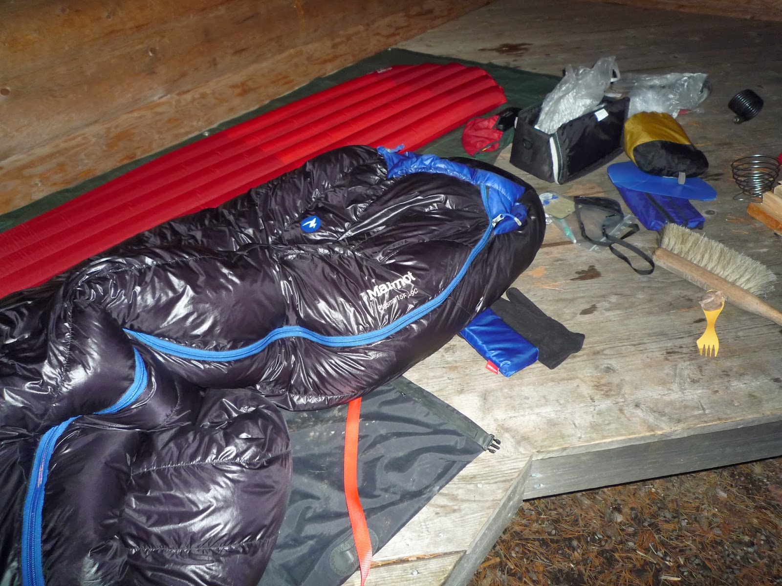
We drove to Valkeala and camped in the Pyörämäki carpark. A mean wind made pitching the tents an unpleasant race against frozen fingers, our headtorches illuminating little beyond snowflakes blasted by the wind. I built a little wall of ploughed up snow lumps around the windward side of my little tent, past experience having shown winter is not really its element and the wind can drive snow under the fly and through the mesh inner. Joel retreated to bed in his more sensible for the weather Hilleberg, whilst I brewed a cup of tea and listened to the Kermode and Mayo film reviews on my iPod. I'm currently reviewing a ridiculously fine Mountain Equipment sleeping bag for UKclimbing.com, so despite the foul weather outside the tent, once in that I was supremely cosy and slept like a log.

Joel, being a civilised chap, had told me not to wake him too early but he needn't have worried. Having not set an alarm, and warm in a sleeping bag that must be about as good as sleeping bags get, I woke late myself. The Jetboil didn't exactly roar, despite the gas cartridge having spent the night inside the bag with me, but I made some tea, ate a sandwich and put some luke warm water in the flask for later. Joel drank some half frozen juice for his breakfast. In the grey, windy half-light of a miserable morning, finding the nearest all day petrol station buffet seemed not a bad idea, but we're made of sterner stuff, or at least like to think so. We trekked over to the cliff through the snow-caked forests. Having not visited Pyörämäki before, Joel led the main fall, climbing it smoothly and finding pliant ice. For my lead we stumbled over to what I've nicknamed the bridge climb. A huge detached boulder needs to be overcome first. Last time I did this by struggling up the offwidth formed between the boulder and the main cliff, mixed-stylee. This time crusty, cruddy ice was dripping down the boulder allowing for some precarious but easier climbing onto its top. From here more normal ice forms the 'bridge' back onto the main cliff, where the ice continues up more easily before raring up again for the last five or so metres of vertical. It's a fun climb, and a doubled 60 mtr rope only just gets you back down again, so long again by Finnish standards.

Pyörämäki
With one lead each dispatched we headed back to the car. At first the intention was lunch and warm drinks then onto another venue, but more of the grey cold day had passed than we had realised. By the time we got to the Valkeala ABC it was apparent that there really wasn't enough daylight to go on to another crag. And with that realisation I ordered a burger and Joel went over to check out what delights their lunch buffet had to offer...