 Since moving to Sheffield nearly a year ago I’ve been getting out into the Peak District and beyond quite a lot, but this has been mainly focused on climbing. I’ve ridden a lot for commuting during the week, keeping my cycling legs ‘in’ that way, but have had few opportunities for riding for pleasure. So now having finished my course, and having some time, I decided to get out and explore the Peak by bike. I didn’t want to ride on roads but I sold my trusty old mountain bike as part of our massive ‘life-streamlining’ before we moved from Helsinki. Hence I was going to need to find a route that I could do on my cyclocross bike as besides my roadie, that was the tool to hand.
 |
| On the trail in the White Peak. |
 |
Cromford Mill - first sparks
of the industrial revolution. |
There is definite sweet spot for off-road riding on a cyclocross bike (CX). Too smooth and you might as well be road biking on a lighter, faster bike. Too rocky and technical and it just feels like your teeth are going to rattle out of your head and you just want a mountain bike with suspension. In England and Wales the law helps define that sweet spot though; bikes have no right of way on footpaths, you are only allowed to ride on bridleways. In many parts of the country, bridleways are often farm tracks – they can be rough or muddy but in rural areas they usually are drivable for a Landrover or a tractor and the determined CX rider. The route I took followed bridleways throughout, so I was fully 'legal', although much of it made use of more modern cycle routes using old, dismantled railways lines - thanks to the brilliant Sustrans organisation that is creating a network of long distance routes across the UK for non-motorised traffic.
 I started south of Chesterfield in the town of Clay Cross - my wife had to go that way for work that morning so it got me quickly away from Sheffield and towards some unfamiliar terrain. After the first 15 kms or so on quiet country lanes I dropped down into the Derwent valley just south of Matlock. Crossing the river and the Cromford Canal at High Peak Junction you get onto the High Peak Trail, and old railway line and now a national cycle route. You generally think of railways as being flat or nearly so, which makes dismantled ones such great cycle routes, but this is not the case here! The 19th century engineers needed to include massive inclines to get the railway up out of the river valley. Static locomotives were used to help trains haul or lower their loads up or down these inclines. They are not so steep as to be impossible to ride, but they are quite unlike road climbs for the cyclist: arrow straight and of a completely consistent angle, there is really nowhere to hide and no brief easings of angle as you toil up them.
 |
| Above the inclines. |
 |
| On to the Pennine Bridleway. |
The inclines take you up above the Matlock valley where you can see numerous quarries, abandoned and still working, and factories and their chimneys - again both empty and still in use. It is a lovely, verdant valley but it set a theme that is ever present in the Peak District: although now a rural area of great beauty, there are signs of past industry everywhere. It's strange but as the economy has changed so much in the post-war period, large parts of Britain have in effect been "re-wilded", or at least "re-ruralfied". Places which were once alive with the industry of both workers and their capitalist bosses; places of production, social conflict and social progress have slipped back into being rural backwaters where once again agriculture is the main industry. It is now the turn of people in the Far East and the Global South to go through those huge social and economic changes that took place in the valleys of the Peak District 18th and 19th centuries.
Once out into the open countryside of the Southern Peak, the High Peak trail allows rapid smooth riding westwards through limestone country. Limestone is not my favourite rock for climbing on, but it does mean wonderful wild flowers. The cuttings and banks of the railway line were alive with yellows, blues, pinks, purples and more, and buzzing with insect life. Occasionally I could see beautiful Common Orchids growing. The wildlife might not be as exciting as you might see in Finland, but the odd deer, rabbit and voles came into view and hovering kestrels were ever present. The High Peak trail above the inclines also includes the starting point of the Pennine Bridleway - a newish long distance path that will take the mountain biker or horse rider all the way to Scotland if they wish, roughly paralleling its older and better known sibling, the Pennine Way. I would follow the Pennine Bridleway until lunch time on the second day, when I would swing back east towards Sheffield on the Trans-Pennine Trail.
When the High Peak Trail merges with the Tissington Trail at Parsley Hay station, it swings northwards. The station is now a bike hire place, National Park info office and cafe - the coffee and chocolate tiffin is to be recommended.
 |
New and old industry
above Cheedale. |
Perhaps 10 kms north of Parsley Hay the disused railway meets still used rails, so just before this the trail, now solely the Pennine Bridleway, leaves the cuttings and embankments of the ex-railway and follows quiet lanes and farm tracks before dropping dramatically (read: really quite exciting on CX) into the amazing limestone gorge of Cheedale. Cheedale is again a place of old industry now going backwards to rural backwater. That industry left another old railway route through tunnels and over bridges down the gorge, which now makes the lovely bike and walking route, the Monsal Trail. Modernity now comes to Cheedale in the form of some of the hardest sports climbs in the UK on the various limestone walls. But the my route just crossed the Monsal Trail and the river, going north straight up and out of the dale via a beautiful but very steep meadow - the first place I had needed to get off and push.
North of Cheedale was some of what felt like the least travelled parts of the route that I followed. For a few kms the trail felt more like a footpath than bridleway but, on the other hand, despite needing to crash through vegetation nearly choking the path in places (fortunately not too many nettles!) it gave some really good singletrack riding in places.
 |
| The limestone gorge of Cheedale. |
 |
| There is a trail there somewhere! |
 |
| First push, out of Cheedale. |
 |
| Traversing Mount Famine. |
The Peak District is made up of two quite distinct visible geologies - the White Peak, the limestone predominantly in the south, and the Dark Peak, the gritstone to the north. By now with the afternoon pressing on, the route followed quiet lanes and started to climb towards the dark bulk of the Kinder plateau. At some point a line is crossed and the drystone walls are now made of the brown grit and not the white and greys of limestone. Crossing the high road between Chapel-en-le-Frith and Castleton marks a sudden change in the feel of the trail; the next section that traverses the western flanks of Kinder at over 400 mtrs of height is really mountain-bike country.
I didn't have a mountain bike, although I like to think I impressed the the passing MTBers with my doggedness (they were probably laughing at... not with...!). The Pennine Bridleway is an impressive path at this point but it is tough technical riding in parts as you traverse towards the wonderfully named Mount Famine, a spur coming down from Kinder. I pushed more here than anywhere else on the ride, but I guess I still managed to ride 70 percent of this section. The descent down into the village of Hayfield was excellent fun, although I suspect would have been even more fun with wide bars, hydraulic brakes and 140 mms of suspension up front!
 |
| Into the Dark Peak, tough going on the flanks of Kinder. |
 |
| Looking back to Hayfield and Mount Famine. |
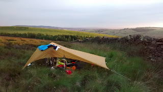
Hayfield is lovely, I had a pie and pint in the pub, stocked up on supplies from a shop and left the town following the trail very steeply up onto Lantern Pike. Once the local boisterously good-natured Scout troop that had hiked up there left, I was all alone at the top so it seemed as good a spot as any to quietly put up my tarp and camp for the night. The views of the sun setting over Manchester to the west and lighting up the slopes of Kinder to the east were exactly the type of thing that makes wild camping worth it, even in a country where it is not exactly legal.
 |
| Evening light on Kinder, with Kinder Downfall just visible. |
 |
| Sunset over Manchester and the Irish Sea. |
 |
| Breakfast in bed. |
 I woke up in wee small hours hearing rain on the tarp, but I stayed dry and warm under it and the morning dawned blue and cloudless. Following the Pennine Bridleway over some more hills and then plunging down towards Glossop was good riding. In Glossop, I finally left that route when it is crossed by the Trans-Pennine Trail (TPT). This long distance route goes from the Irish sea near Liverpool to North Sea at Hull, but I was about to follow it to its highest point as I crossed back from the west to the eastside of the Pennines. The route up Longdendale follows old railway track again so its very straight and smooth. The path leaves the old track where the rails used to go into the now closed Woodhead tunnel. The TPT instead crosses the busy A628 (it is busy with lots of big trucks - take care!) and goes steeply up a hillside (more pushing) before following a rough bridleway up to the top of pass. The Woodhead Pass is high and quite wild in a way, but definitely not "wilderness": a busy road goes over it, Longdendale has big pylons carrying electricity cables that then go under the pass using the old railway tunnel. There are also reservoirs and dams in the valley bottom. But looking up to the cloughs and crags on the northern edge of Bleaklow you can see the wild country.
 |
| Getting going on day 2. |
 |
| Rough tracks giving slower but fun riding. |
 |
| Looking toward Manchester - I can see my old uni! |
Across the Woodhead pass and back in Yorkshire, the TPT plunges down into the Upper Don Valley and picks up the old railway line where it emerges from the eastern end of the Woodhead Tunnels. It’s then old railway - flat, straight and fast -through Pennistone, Deepcar and taking you almost all the way back into Sheffield. Once back in city centre there just one more steep hill to slog up and I was home in time to go and pick the kids up from school.
 |
| Climbing out of Longdendale - the Woodhead tunnel is somewhere deep below my tyres. |
 |
| Traffic jam on the Trans-Pennine Way. |
 |
| Back into Yorkshire, all downhill now. |
Overall I did 151 kms in two days, of which probably only 25 kms was on paved road, arriving home sweaty, dirty and (perhaps unusually for Northern England) dry but slightly sunburnt.
Snapshot from Strava showing the route and profile - day 1:
Snapshot from Strava showing the route and profile - day 2:
 Since moving to Sheffield nearly a year ago I’ve been getting out into the Peak District and beyond quite a lot, but this has been mainly focused on climbing. I’ve ridden a lot for commuting during the week, keeping my cycling legs ‘in’ that way, but have had few opportunities for riding for pleasure. So now having finished my course, and having some time, I decided to get out and explore the Peak by bike. I didn’t want to ride on roads but I sold my trusty old mountain bike as part of our massive ‘life-streamlining’ before we moved from Helsinki. Hence I was going to need to find a route that I could do on my cyclocross bike as besides my roadie, that was the tool to hand.

 I started south of Chesterfield in the town of Clay Cross - my wife had to go that way for work that morning so it got me quickly away from Sheffield and towards some unfamiliar terrain. After the first 15 kms or so on quiet country lanes I dropped down into the Derwent valley just south of Matlock. Crossing the river and the Cromford Canal at High Peak Junction you get onto the High Peak Trail, and old railway line and now a national cycle route. You generally think of railways as being flat or nearly so, which makes dismantled ones such great cycle routes, but this is not the case here! The 19th century engineers needed to include massive inclines to get the railway up out of the river valley. Static locomotives were used to help trains haul or lower their loads up or down these inclines. They are not so steep as to be impossible to ride, but they are quite unlike road climbs for the cyclist: arrow straight and of a completely consistent angle, there is really nowhere to hide and no brief easings of angle as you toil up them.


 I woke up in wee small hours hearing rain on the tarp, but I stayed dry and warm under it and the morning dawned blue and cloudless. Following the Pennine Bridleway over some more hills and then plunging down towards Glossop was good riding. In Glossop, I finally left that route when it is crossed by the Trans-Pennine Trail (TPT). This long distance route goes from the Irish sea near Liverpool to North Sea at Hull, but I was about to follow it to its highest point as I crossed back from the west to the eastside of the Pennines. The route up Longdendale follows old railway track again so its very straight and smooth. The path leaves the old track where the rails used to go into the now closed Woodhead tunnel. The TPT instead crosses the busy A628 (it is busy with lots of big trucks - take care!) and goes steeply up a hillside (more pushing) before following a rough bridleway up to the top of pass. The Woodhead Pass is high and quite wild in a way, but definitely not "wilderness": a busy road goes over it, Longdendale has big pylons carrying electricity cables that then go under the pass using the old railway tunnel. There are also reservoirs and dams in the valley bottom. But looking up to the cloughs and crags on the northern edge of Bleaklow you can see the wild country.


